Hey everyone! Welcome to the second edition of Segovia Outdoors! After our journey last edition, you may want to tackle something a little more adventurous. Luckily for you, that’s exactly what we’ll do this week! Our hike today takes us up to La Peñalara, the tallest mountain in the Sierra de Guadarrama, ending at the Refugio Chozo Aranguez. I always look forward to doing this hike with friends – it’s an amazing way to spend a weekend!
Disclaimer: this hike is certainly difficult, at 15km and 731m in positive elevation change. Make sure you’re in proper shape to fully enjoy it!
First, we need to pack our gear for the hike. For bare essentials (food and water), we’ll pack 2 liters of water (pick up one of these at Dia), some sandwich ingredients (ham, baguette, cheese), and some fruit (apples, mandarins, or bananas). Make sure to also pack an extra jacket and socks for the Refugio – it’ll be cold up there! You’ll also want at least 3 euro cash for the bus and maybe a little extra for churros after!
For the hike, wear enough to keep you warm throughout the hike, and use layers! If you only rely on one big jacket, you’ll always feel too hot or too cold. I always wear 2 or 3 sweatshirts to make sure I can adjust properly. Additionally, wear hiking boots, especially in the winter! This will keep your ankles safe and toes warm!
To get to the trailhead, we’ll do the same as last time. The hike in total should take you about 6 hours, so plan in advance your busses to and from San Ildefonso. Take the M8 to the Fabrica Cristal station in San Ildefonso, then take the second street on the left until you hit the trailhead. From here, we’ll continue along the wall and until we hit our first crossroads. Continue in the same direction until you hit the first river crossing. Here, take Senda de los Carneros, the first trail on the right then a quick left, and continue along the river until you hit a dirt road. This road takes you to our second major crossing, Vado de Oquendo, where you’ll find multiple ponds and a river. From here, cross the river and take the middle trail up, following the small tributary creek. Continue on this trail until it joins a dirt road, after crossing a dirt road once. At this point, we’re already ⅔ of the way to the Refugio!
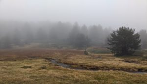
From here, follow the dirt road until it splits into two. The left will take you to Alto de Los Poyales, along the Peñalara ridge. However, we’re gonna take the right, going to Refugio Chozo Aranguez. From here, the trail will take you directly to the Refugio! On the last stretch before the hut, watch where you step, as much of the ground is marshy due to the melting snow from the Peñalara.
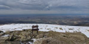
Once at the Refugio, you have a few options. Many times, I enjoy just chilling in or around the hut, taking in the views of a distant Segovia below and the towering Peñalara above. However, the adventurous spirit in me always wants to get to the top. Here’s how: Follow the trail on the opposite direction you came in, looking for rocks stacked on top of each other. For about 1km the trail continues evenly, then shoots up the side of the mountain with sharp switchbacks. Follow these until you reach the ridge of the Penalara, then walk along to the top. While it does not seem far away, at only 2.4 km, it takes about an hour and a half to do one way, but I would highly recommend it if you deem it possible!
To return to San Ildefonso, simply retrace your steps all the way back to the bus station! If you want, you can always take a later bus and get some churros at Churrería la Fama, but make sure to bring extra cash!
One skill which serves me well in hiking complex trails as this one is using a map and compass, two tools which your phone holds. To practice, open a map app and try to orient it in the direction you’re facing. Then, try to match buildings or natural features on the map and in your view. Sometimes, though, your GPS will be out of signal and your phone will not locate you on the map. In this case, choose 3 or 4 features on the map and find them in real life. From here, you can triangulate your position on the trail by drawing lines from each at the angle you see and mark where they intersect. Knowing this skill is crucial to hikes like these, where cell service is dodgy and the trail takes many turns, but as you practice you’ll continue to improve!
I hope you can use this edition of Segovia Outdoors to throw together a fun weekend plan! Until next time, keep on exploring!
- Justin Morgan


